About Boyalı Village
Boyalı lies 29 km from the city of Nevşehir and 10 km from the town of Ürgüp, on the highway running from Ürgüp towards Yeşilhisar and İncesu. It is bordered by Aksalur to the north, the provincial boundary of Kayseri to the east, Karacaören to the west, and Karain, İltaş and Akköy to the south.
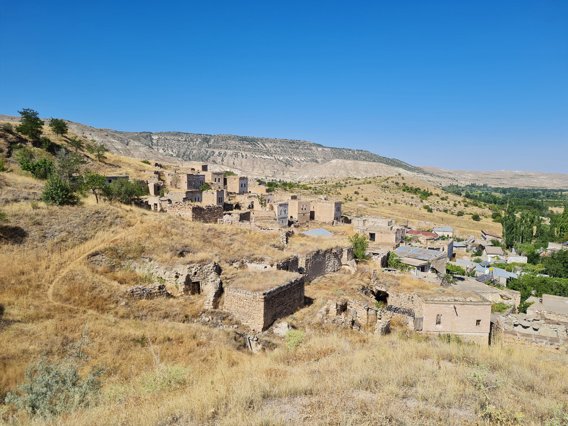
The old settlement was built in descending terraces along the slopes of a soft tuff hill known locally as “Kızılyer Mevkii.” Houses of masonry construction were added in front of rock-cut chambers, and together they trace a concave arc along the steep, narrow lanes.
The population of the village stood at 350 in 1985 and has since fallen to 79. Livelihoods depend on farming and animal husbandry; the principal crops are potatoes, wheat, chickpeas, apples and grapes. The village lies within a Third-Degree Natural Conservation Site, one of the protected areas of Cappadocia, and eight of its buildings are registered monuments.
The Origin of the Village Name
The village appears as “Boyallı” — spelled with a double l — in the Ottoman Harîta-i Ürgüb of 1287 (1870) and in official records of 1928. This spelling does not sit well with the popular explanation that the name derives from boya, the Turkish word for dye, and no trace of a dye works has been found in the village. It is more likely that the name goes back to the Yörük community recorded in Ottoman archives as “Boyalı”, and that it was formed to mean “the place of the Boyalı.”
History of the Village
The known past of the village reaches much further back than the written records. The rock-cut churches, wine presses and dwelling chambers at the Ören locality belong to the Byzantine period. The abundant potsherds visible on the surface of the mound in the same area suggest that settlement here may extend to still earlier layers; since no scientific excavation has been carried out on the mound, however, no firm dating is yet possible.
The earliest documents naming the village date from the sixteenth century. The endowment register of the mosque records that the estate of the village of Boyalu had long belonged to the waqf, and that in 1584 the foundation was administered by Kadı Hüseyin.
The Konya Provincial Yearbook of AH 1290 / CE 1873 records the village as having 49 households and a population of 189. A register of the Directorate General of Foundations dated AH 1258 / CE 1842 describes a dispute over the appointment of a successor to Seyyid Veliyyüddin, who had served as preacher at the Bayezid Mosque Foundation in the village for a daily wage of one akçe, and the assignment of an inspector to examine the matter.
An archival record of AH 1325 / CE 1907 reports that the official opening of the newly built primary school in Boyalı was timed to coincide with the anniversary of the sultan's accession to the throne. The stone building of the village school was erected in 1930, closed in the 1990s when pupils began to be bused to schools elsewhere, and has served as the village hall since 2015.
The population peaked at 632 in 1945 and has declined steadily ever since, under the combined effect of migration and the disaster designation: 350 in 1985, and 79 today.
Map of the Village
The numbered markers show the stops in the village and at the Ören locality. Tapping a marker opens its name, a short note and a link to directions.
Ottoman periodBoyalı Village Mosque
Standing at the centre of the village, the mosque is rectangular in plan, aligned north–south, and built of local tuff in masonry technique. The cream-coloured stone was quarried in the vicinity of Topuz Dağı.
According to the inscription above the entrance, the mosque was first built by a benefactor named Bayezid and completed in AH 990 / CE 1582–83. The inscription goes on to relate that the building later collapsed and fell into ruin, and that in AH 1290 it was rebuilt in ornamented form by Hacı Osman Ağa, an official of the Ottoman court.
The Mihrab
The mosque holds a distinctive place among the mihrabs of Nevşehir. Set into the thickness of the wall at the centre of the southern side, the mihrab is built of cut stone and measures approximately 1.95 m in width and 3.80 m in height.
What makes it exceptional are its revolving colonnettes. The cylindrical colonnettes framing the niche on either side rest within cone-shaped channels at the capitals, and can turn on their own axis within these channels. Although comparable examples are found in mosques across Anatolia, the mihrab of Boyalı Village Mosque is the only one among the mihrabs of Nevşehir whose colonnettes have not lost this property and still genuinely revolve. The capitals bear indistinct forms recalling acanthus leaves, together with reliefs ending in volutes.
Look closely. Examine the slender columns flanking the mihrab. Standing in place for centuries, these stone colonnettes were carved so as to turn within the sockets that hold them.
The Bath House
The sixteenth-century endowment register of the mosque records that, alongside the village estate, four plots of land and a bath house were made over to the foundation. The same record notes that in 1584 the foundation was administered by Kadı Hüseyin.
This single line tells us that Boyalı, today a small village, was in the sixteenth century a busy settlement large enough to sustain a bath house of its own. The building has not survived.
The Village Fountains
Two historic fountains survive in the village, built ten years apart and both bearing legible inscriptions.
Fountain No. 1 (AH 1299 / CE 1881)
Situated to the north of the mosque, it is built of rubble stone in masonry technique with a single arch, and measures roughly 3.7 m in width, 3.8 m in height and 1 m in depth. According to the inscription set within an oval cartouche on the face panel, the fountain was a pious endowment made by a lady, the daughter of the late Dilaver Pasha and the wife of the late Hacı Emin Pasha. Its original trough has since been replaced by one of ceramic tile.
Fountain No. 2 (AH 1288 / CE 1871)
Standing within the traditional residential fabric, adjoining the courtyard wall of a house, it is built of local tuff in masonry technique with a single arch, and measures roughly 3.5 m in width, 3.7 m in height and 0.8 m in depth. The inscription sits within a polygonal cartouche on the face panel, with a small niche for drinking cups below it. A second arch resembling an eaves course runs above the main arch, with a water cistern behind. The inscription reads only Bismillah and the date AH 1288. As the level of the road has risen over time, the fountain now stands at street level.
Byzantine periodBoyalı Church
Some 10 metres west of the village mosque, the church was cut into the cone of a large fairy chimney. Today it survives as a single rock-cut chamber measuring roughly 15 × 5 metres, its ceiling shaped as a rock-cut barrel vault.
The church was clearly once decorated with wall paintings of high quality. The paintings have been largely destroyed, but several scenes can still be made out:
- The meal at the house of Matthew/Levi — Jesus seated at table with tax collectors and sinners (Matthew 9:10, Mark 2:15, Luke 5:29).
- The Virgin Mary with the infant Jesus in her arms.
- The Iota-Chi (ΙΧ) monogram — formed from the initial Greek letters of the name of Jesus, the ring enclosing it symbolising eternity, while the shaft below indicates that the monogram was carried in the hand, as a processional cross or a labarum.
Byzantine periodThe Ören Byzantine Settlement
Roughly 600 metres east of the village square, a Byzantine settlement extends along the face of the rock. The villagers call this area “Ören mevkii” — the place of ruins.
What sets Ören apart from the many rock-cut churches of Cappadocia is that what survives here is not a set of isolated monuments but an entire village. Around the two rock-cut churches dated to the Byzantine period lie wine presses, rock-cut chambers, kitchens, storerooms and dovecotes. Places of worship, areas of production, dwellings and graves were all set into the same masses of rock. Taken together, the remains give the impression of a genuine Byzantine village.
The two churches stand adjoining one another, and their entrances open onto a shared courtyard. Rock-cut graves lie within this courtyard.
Dovecotes, Wine Presses and Rock-Cut Graves
Dovecotes
The small cavities carved into the rock faces, reached through narrow openings, served for keeping pigeons. Pigeon guano was for centuries the principal fertiliser for the vineyards and gardens of Cappadocia, and the dovecotes were therefore made with as much care as religious buildings, their façades in places emphasised with lime wash and decoration.
Wine presses
These are two-tiered basins cut into the rock, where grapes were trodden and the must collected. Grapes were crushed in the broad, shallow upper basin, and the must ran through a channel into the deeper, smaller vat below. Grapes are still grown in Boyalı today, evidence that this tradition of production has continued without interruption.
Rock-cut graves
Graves were cut into the rock floor of the courtyard shared by the two churches. Their position directly in front of the churches shows that the area also served as a burial ground.
Kitchens, storerooms and rock-cut chambers
Chambers belonging to everyday life are ranged around the churches. These kitchens, storerooms and living quarters are what turn Ören from a place of worship into a living settlement. A church, a wine press beside it and a storeroom a few steps further along, all set into the same rock face, allow the daily order of this community to be read directly.
Ören Church 1 (The Columned Church)
Its entrance facing south, the church was cut into a fairy chimney. Its apse faces due east.
The ceiling is carved in the form of a dome, and a considerable quantity of red madder pigment survives in the interior. A six-lobed circle was drawn in madder within the dome. Niches were cut into the walls on either side of the apse; the load-bearing column supports of the church are broken.
The stonework of the interior is of the highest craftsmanship, with decorative niches set into the walls. The door opens directly into the nave, and no narthex has been observed.
Ören Church 2 (The Church of the Carved Cross)
It lies to the north-east of Ören Church 1. Its entrance faces south, and it too was cut into a fairy chimney. Half of its ceiling has collapsed.
The apse faces north-east, which is unusual; an opening facing due east, however, was cut behind the apse at a later date. The ceiling is carved in the form of a dome and retains slight traces of red madder pigment.
The feature that gives the church its name is on the ceiling: a cross carved in relief in the stone distinguishes it from the other church. The stonework of the interior is of fine craftsmanship, and decorative niches were cut into the walls. The door opens directly into the nave, and no narthex has been observed.
The Ören Mound
A mound (höyük) lies immediately beside the rock-cut structures. The existence of the mound and the large quantity of potsherds visible on its surface are beyond doubt. Which period the mound belongs to, on the other hand, has not been settled; opinions on its dating differ, and the absence of any scientific excavation on the site makes a firm conclusion difficult.
It is likely that the mound holds a Byzantine settlement contemporary with the rock-cut structures around it. The surface finds, however, also point to the possible presence of traces of much earlier settlement on the same hill, and in this respect the mound remains a subject of research.
What is certain is this: Ören bears the traces not of a single period but of several settlement layers laid one upon another. Scientific investigation of the mound may carry the story of Boyalı considerably further back than is known today.
Notes for Visitors
The suggested route takes approximately 1.5–2 hours on foot.
- The mosque
- Fountain No. 1 — immediately north of the mosque
- Boyalı Church — 10 m west of the mosque
- The traditional residential fabric and Fountain No. 2
- The Ören Byzantine Settlement and Mound — 600 m east of the village square
Please note
- The ceilings of the churches at Ören have partly collapsed and their load-bearing column supports are broken. Take care when entering the interiors.
- The interior of Boyalı Church is filled with rubble and the floor is uneven.
- A disaster designation is in force over the old village fabric because of the risk of rockfall; do not enter abandoned buildings.
- The traces of madder pigment and the wall paintings on the rock surfaces are extremely fragile. Do not touch them, and do not photograph them with flash.
- There is no accommodation in the village; the nearest options are in the centre of Ürgüp.
- The potsherds on the surface of the mound are of scientific value. Do not disturb the finds and do not collect them.
References
- Dırık, İ. Kültür Katmanları Üzerinden Kırsalı Okumak: Kapadokya Bölgesi Ürgüp Köyleri Örneği (doctoral thesis).
- Ürgüp Boyalı Köyü Camii Mihrabı (article).
- Ürgüp ve Çevresindeki İslami Eserler.
- Konya Provincial Yearbooks, AH 1286 / CE 1869 and AH 1290 / CE 1873.
- Ottoman Archives of the Prime Ministry, MF. MKT. 1021/70 (AH 1325).
- Archives of the Directorate General of Foundations, D. 292, S. 6 (AH 1258).
- Oflaz, M. (1992).
- Eravşar, O. (1993).
- Field survey and oral interview notes (Boyalı Village, 2022–2023).